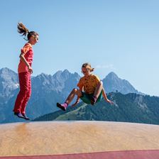
 Adventure hike Kleine Salve
Starting point: Mountain station Kleine Salve
Destination point: Mountain station Kleine Salve
EasyA tour around the Salvenwald forest
Elevation uphill:
420 m
420 m
Highest point:
1565 m
1565 m
Distance:
7,1 km
7,1 km
Time:
2:30 h
2:30 h
 Hängebank Rastplatz Lehrpfad
Starting point: Parkplatz Kasplatzl
Destination point: Parkplatz Kasplatzl
Easy
Elevation uphill:
330 m
330 m
Highest point:
1460 m
1460 m
Distance:
7,8 km
7,8 km
Time:
2:50 h
2:50 h
 4th stage KAT Walk Family
Starting point: St. Johann in Tirol - centre
Destination point: St. Ulrich am Pillersee - centre
EasyStage 4: St. Johann in Tirol - Fieberbrunn
Elevation uphill:
500 m
500 m
Highest point:
1200 m
1200 m
Distance:
6,5 km
6,5 km
Time:
3:30 h
3:30 h
 Kirchberg - Schafelberg
Starting point: Centre Tourist office
Destination point: Centre Tourist office
Easy
Elevation uphill:
860 m
860 m
Highest point:
1679 m
1679 m
Distance:
9,3 km
9,3 km
Time:
5:00 h
5:00 h
 06 Sonnseitrunde
Starting point: Tourist office PillerseeTal, Dorfplatz 1, 6391 Fieberbrunn
Destination point: Tourist office PillerseeTal, Dorfplatz 1, 6391 Fieberbrunn
EasyOn the sunny side of the valley through rural hamlets and meadows. Always in view, the striking mountains around Fieberbrunn: Spielberg, Wildseeloder, Wilder Kaiser.
Elevation uphill:
160 m
160 m
Distance:
8,1 km
8,1 km
 Baumooskogel via Haberberg
Starting point: Kirchdorf Center
Destination point: Kirchdorf Center
EasyHike along old paths with magnificent views past farmhouses and alpine pastures.
Elevation uphill:
914 m
914 m
Highest point:
1502 m
1502 m
Distance:
19,3 km
19,3 km
Time:
7:15 h
7:15 h
 Panorama-Runde
Starting point: Kalswirt
Destination point: Kalswirt
EasySehr leichte Walkingstrecke mit vielen Einblicken in die Natur
Elevation uphill:
190 m
190 m
Highest point:
964 m
964 m
Distance:
7,8 km
7,8 km
Time:
2:30 h
2:30 h
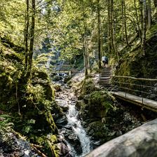 Eifersbacher Waterfall Starting point St. Johann in Tirol center
Starting point: St. Johann in Tirol - center
Destination point: St. Johann in Tirol - center
EasyBurbling Gently and Roaring Loudly: These are the Two Faces of the Eifersbacher Waterfall.
Elevation uphill:
277 m
277 m
Highest point:
880 m
880 m
Distance:
8,7 km
8,7 km
Time:
2:55 h
2:55 h
 Lodron
Starting point: Mautstation Windautal
Destination point: Mautstation Windautal
EasyUnspoilt nature!
Elevation uphill:
1125 m
1125 m
Highest point:
1925 m
1925 m
Distance:
20,0 km
20,0 km
Time:
8:30 h
8:30 h
 Hängebank Hislegsee
Starting point: Ehrenbachhöhe Bergstation
Destination point: Ehrenbachhöhe Bergstation
Easy
Elevation uphill:
250 m
250 m
Highest point:
1930 m
1930 m
Distance:
5,1 km
5,1 km
Time:
1:50 h
1:50 h